IT Article -- Global Positioning System
Ms. Chetna Tailor Mr. Roshan Bhakta |
WHAT IS GPS?
The Global Positioning System (GPS) is a navigation and precise-positioning tool. Developed by the Department of Defense in 1973, GPS was originally designed to assist soldiers and military vehicles, planes, and ships in accurately determining their locations world- wide. Today, the uses of GPS have extended to include both the commercial and scientific worlds. Commercially, GPS is used as a navigation and positioning tool in airplanes, boats, cars, and for almost all outdoor recreational activities such as hiking, fishing, and kayaking. In the scientific community, GPS plays an important role in the earth sciences. Meteorologists use it for weather forecasting and global climate studies; and geologists can use it as a highly accurate method of surveying and in earthquake studies to measure tectonic motions during and in between earthquakes.
HISTORY OF GPS:
Department of Defense (DOD), Ivan Getting, and the Massachusetts Institute of Technology (MIT). Originally consisting of 11 orbiting satellites, the GPS--official name NAVSTAR (Navigation System with Timing And Ranging)--was launched by DOD in 1978 strictly for military use. The idea for the system began much, much earlier. In fact the basic idea of GPS navigation can be traced back centuries to the first explorer who asked the question, "Where am I?" The technology of GPS history, however, first emerged in the 1950s.
In 1957, Russia launched a satellite (Sputnik) into space. After the launch, MIT researchers noticed that as Sputnik orbited the planet, its radio signal varied in strength. As it approached their position, the signal strength increased. When the satellite departed the MIT researchers' position, the signal strength decreased. From this increase and decrease of the radio signal, the MIT researchers could determine Sputnik's exact orbit. This recognition that radio signals from a satellite, or "artificial star" could determine distinct positions on the ground was truly the launching pad of the GPS system.
Even before that, however, the seeds for the GPS technology were being planted. In 1951, Dr. Ivan Getting, a graduate of MIT student and a Rhodes Scholar from Oxford, put his Ph.D. in astrophysics to use at Raytheon. The Air Force requested a guidance system for a proposed ICBM traveling via railroad. In response to this request, Dr. Getting developed the first three-dimensional, position-finding system based on time difference of arrival. This system became the basis for the future GPS.
The deployment portion of the GPS history began in 1973 with the decision to develop a satellite navigation system based on existing technology of the U. S. Air Force and the U. S. Navy. The system went through extensive testing during the next three years. In 1977 the first transmitters were installed on the surface of the Earth and tested--even though no satellites have been launched yet. The transmitters were dubbed Pseudolites (pseudo satellites).
Between 1978 and 1985, eleven satellites were launched into space and put into position. In 1979, the decision was made to increase the number of satellites to 18. In 1980, the first Block I satellite was launched. This "bird' had sensors specifically designed to detect atomic explosions, and was placed in orbit as a means of monitoring the Soviet Union's compliance with the 1963 agreement with the United States to refrain from nuclear testing.
Also in 1980, the onboard atomic clocks, the most accurate timepieces in the world, were activated. Developed by physicists, atomic clocks measure time by the change in energy levels of electrons. These clocks are stable, continuous, and accurate to a nanosecond, or one-billionth of a second.
In 1983, the GPS ceased being solely a military system and was made available for public use. President Ronald Reagan declassified the GPS system in response to a tragedy involving a civilian airplane. Korean Airline flight 007 got lost over Soviet territory and was shot down by Soviet fighters. In 1986, the Challenger space shuttle tragedy halted space shuttle launches, and thereby delayed the GPS system, because shuttles were supposed to transport the new Block II satellites. Eventually, Delta rockets, the original transport, were put back into use to launch the satellites, and in 1988, the decision was made to increase the number of satellites to 24, because functionality with 18 satellites was still limited.
Though the GPS system was available for public use, the first Gulf War in 1990 saw temporary deactivation of use by the public, because the military needed more receivers. Public use returned in 1993 along with the decision that the GPS system would be available free of charge to the entire world. Full Operational Capacity (FOC) was achieved in July of 1995 with the placement and activation of the last of the 24 satellites.
Since 1995, GPS history has seen considerable technological advancement. More satellites have been put into orbit, increasing both availability and accuracy. Previously GPS could locate a subject within 100 meters. That accuracy improved to finding subjects within 10-15 meters, and at present can be measured within centimeters in some cases. Availability improved from utilization in military and the position-required industries of aviation, nautical navigation, and land surveying, to include many personal applications. With the use of a fairly inexpensive receiver, employers use GPS to track their fleet of vehicles, parents use the system to keep track of small children and of disobedient teenagers, and pet lovers use it to keep track of their dogs.
HOW DOES IT WORK?
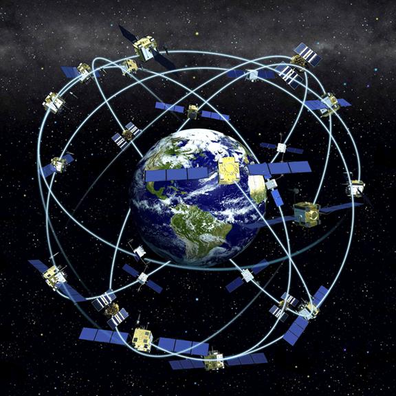
Three distinct parts make up the Global Positioning System. The first segment of the system consists of 24 satellites, orbiting 20,000 km above the Earth in 12-hour circular orbits. This means that it takes each satellite 12 hours to make a complete circle around the Earth. In order to make sure that they can be detected from anywhere on the Earth's surface, the satellites are divided into six groups of four. Each group is assigned a different path to follow. This creates six orbital planes, which completely surround the Earth.
These satellites send radio signals to Earth that contain information about the satellite. Using GPS ground-based receivers, these signals can be detected and used to determine the receivers' positions (latitude, longitude, height.) The radio signals are sent at two different L-band frequencies. L-band refers to a range of frequencies between 390 and 1550 MHz. Within each signal, a coded sequence is sent. By comparing the received sequence with the original sequence, scientists can determine how long it takes for the signal to reach the Earth from the satellite. The signal delay is useful in learning about the Ionosphere and the Troposphere, two atmospheric layers that surround Earth's surface. A third signal is also sent to the receivers from the satellite. This signal contains data about the health and position of the satellite.
The second part of the GPS system is the ground station, comprised of a receiver and antenna, as well as communication tools to transmit data to the data center. The omni-directional antenna at each site, acting much like a car radio antenna, picks up the satellite signals and transmits them to the site receiver as electric currents. The receiver then separates the signals into different channels designated for a particular satellite and frequency at a particular time. Once the signals have been isolated, the receiver can decode them and split them into individual frequencies. With this information the receiver produces a general position (latitude, longitude, and height) for the antenna. Later, scientists to determine different things, including another set of position coordinates for the same antenna, this time with millimeter accuracy, can process the data collected by the receiver again.
The third part of the system is the data center. The role of the data center is two fold. It both monitors and controls the global GPS stations, and it uses automated computer systems to retrieve and analyze data from the receivers at those stations. Once processed, the data, along with the original raw data, is made available to scientists around the world for use in a variety of applications. Since global GPS sites are constructed and monitored by different institutions all over the world, there are many different data center locations.
APPLICATION OF GPS:
Who uses GPS? GPS has a variety of applications on land, at sea and in the air. Basically, GPS is usable everywhere except where it's impossible to receive the signal such as inside most buildings, in caves and other subterranean locations, and underwater. The most common airborne applications are
- for navigation by general aviation and commercial aircraft.
- At sea, GPS is also typically used for navigation by recreational boaters, commercial fishermen, and professional mariners.
- Land-based applications are more diverse. The scientific community uses GPS for its precision timing capability and position information.
- GPS is popular among hikers, hunters, snowmobilers, mountain bikers, and cross-country skiers, just to name a few.
- It is used in automobiles as well like it provides emergency roadside assistance at the push of a button.
Anyone who needs to keep track of where he or she is, to find his or her way to a specified location, or know what direction and how fast he or she is going can utilize the benefits of the global positioning system.
REFERENCES:
http://scign.jpl.nasa.gov/learn/gps1.htm
http://www.maps-gps-info.com/gps-history.html
http://scign.jpl.nasa.gov/learn/gps2.html
http://www8.garmin.com/aboutGPS/applications.html